What glaciers are on earth. Russian glaciers
Glaciers
Glaciers
accumulations of ice that move slowly across the earth's surface. In some cases, ice movement stops and dead ice forms. Many glaciers advance some distance into oceans or large lakes and then form a calving front where icebergs break away. There are four main types of glaciers: continental ice sheets, ice caps, valley glaciers (alpine) and foothill glaciers (foot glaciers).
The best known are sheet glaciers, which can completely cover plateaus and mountain ranges. The largest is the Antarctic ice sheet with an area of more than 13 million km 2, which occupies almost the entire continent. Another sheet glacier is found in Greenland, where it even covers mountains and plateaus. The total area of this island is 2.23 million km 2, of which approx. 1.68 million km 2 is covered with ice. This estimate takes into account not only the area of the ice sheet itself, but also numerous outlet glaciers.
The term "ice cap" is sometimes used to refer to a small ice sheet, but it is more correct to refer to a relatively small mass of ice covering a high plateau or mountain range, from which valley glaciers radiate in different directions. A good example of an ice cap is the so-called. The Columbian Firn Plateau, located in Canada on the border of the provinces of Alberta and British Columbia (52 ° 30 "N). Its area exceeds 466 km 2, and large valley glaciers depart from it to the east, south and west. One of them - The Athabasca Glacier is easily accessible, as its lower end is only 15 km from the Banff-Jasper Highway, and in summer tourists can drive an ATV around the entire glacier.Ice caps are found in Alaska north of Mount St. Elijah and east of Russell Fjord.
Valley, or alpine, glaciers start from sheet glaciers, ice caps, and firn fields. The vast majority of modern valley glaciers originate in firn basins and occupy trough valleys, in the formation of which pre-glacial erosion could also take part. Under certain climatic conditions, valley glaciers are widespread in many mountainous regions of the world: in the Andes, the Alps, Alaska, the Rocky and Scandinavian mountains, the Himalayas and other mountains of Central Asia, and New Zealand. Even in Africa - in Uganda and Tanzania - there are a number of such glaciers. Many valley glaciers have tributary glaciers. So, at the Barnard Glacier in Alaska, there are at least eight of them.
Other varieties of mountain glaciers - cirque and hanging - in most cases are relics of a more extensive glaciation. They are found mainly in the upper reaches of the troughs, but sometimes they are located directly on the slopes of the mountains and are not connected with the underlying valleys, and the dimensions of many are slightly larger than the snowfields that feed them. Such glaciers are common in California, the Cascade Mountains (Washington State), and there are about fifty of them in the Glacier National Park (Montana State). All 15 glaciers The Colorados are classified as karts or hangings, and the largest of them, the Arapaho kar glacier in Boulder County, completely occupies the kar. The length of the glacier is only 1.2 km (and once it was about 8 km long), about the same width, and the maximum thickness is estimated at 90 m.
Piedmont glaciers are located at the foot of steep mountain slopes in wide valleys or on plains. Such a glacier may be formed due to the spreading of a valley glacier (an example is the Columbia Glacier in Alaska), but more often - as a result of the confluence at the foot of a mountain of two or more glaciers descending along the valleys. The Grand Plateau and Malaspina in Alaska are classic examples of this type of glacier. Piedmont glaciers are also found on the northeast coast of Greenland.
Characteristics of modern glaciers. Glaciers vary greatly in size and shape. It is believed that the ice sheet covers approx. 75% of the area of Greenland and almost all of Antarctica. The area of ice caps ranges from several to many thousand square kilometers (for example, the area of the Penny ice cap on Baffin Island in Canada reaches 60 thousand km 2). The largest valley glacier in North America is the 116 km long western branch of the Hubbard Glacier in Alaska, while hundreds of hanging and cirque glaciers are less than 1.5 km long. The areas of foot glaciers range from 1–2 km 2 to 4.4 thousand km 2 (the Malaspina glacier descending into Yakutat Bay in Alaska). It is believed that glaciers cover 10% of the entire land area of the Earth, but this figure is probably too low.
The largest thickness of glaciers - 4330 m - was established near Baird station (Antarctica). In central Greenland, the thickness of the ice reaches 3200 m. Judging by the associated relief, it can be assumed that the thickness of some ice caps and valley glaciers is much more than 300 m, while others measure only tens of meters.
The speed of movement of glaciers is usually very small - about a few meters per year, but there are also significant fluctuations here. After a number of years of heavy snowfall, in 1937 the tip of the Black Rapids Glacier in Alaska moved at a speed of 32 meters per day for 150 days. However, such a rapid movement is not typical for glaciers. In contrast, the Taku Glacier in Alaska has been advancing for 52 years average speed 106 m/year. Many small cirque and hanging glaciers move even more slowly (for example, the Arapahoe glacier mentioned above moves only 6.3 m annually).
Ice in the body of a valley glacier moves unevenly—fastest on the surface and in the axial part, and much slower along the sides and near the bed, apparently due to increased friction and high saturation of clastic material in the bottom and marginal parts of the glacier.
All large glaciers are dotted with numerous cracks, including open ones. Their dimensions depend on the parameters of the glacier itself. There are cracks up to 60 m deep and tens of meters long. They can be either longitudinal, i.e. parallel to the direction of movement, and transverse, running across this direction. Transverse cracks are much more numerous. Less common are radial fissures found in spreading piedmont glaciers and marginal fissures confined to the ends of valley glaciers. Longitudinal, radial and edge cracks, apparently, were formed due to stresses resulting from friction or ice spreading. Transverse cracks are probably the result of ice moving over an uneven bed. A special type of fissures, the bergschrund, is typical of kars confined to the upper reaches of valley glaciers. These are large cracks that occur when a glacier exits a firn basin.
If glaciers descend into large lakes or seas, iceberg calving occurs along the cracks. Fissures also contribute to the melting and evaporation of glacial ice and play an important role in the formation of kams, basins and other landforms in the marginal zones of large glaciers.
The ice of sheet glaciers and ice caps is usually clean, coarse-grained, and blue in color. This is also true for large valley glaciers, with the exception of their ends, which usually contain layers saturated with rock fragments and alternating with layers pure ice. Such stratification is due to the fact that in winter, snow falls on top of the dust and debris accumulated in summer that fell onto the ice from the sides of the valley.
On the sides of many valley glaciers there are lateral moraines - elongated ridges of irregular shape, composed of sand, gravel and boulders. Under the influence of erosion processes and slope washout in summer and avalanches in winter, a large amount of various detrital material enters the glacier from the steep sides of the valley, and a moraine is formed from these stones and fine earth. On large valley glaciers that receive tributary glaciers, a median moraine is formed, moving near the axial part of the glacier. These elongated narrow ridges, composed of clastic material, used to be lateral moraines of tributary glaciers. Coronation Glacier in Baffin Island has at least seven median moraines.
In winter, the surface of the glaciers is relatively flat, as snow levels out all the irregularities, but in summer they significantly diversify the relief. In addition to the fissures and moraines described above, valley glaciers are often deeply dissected by flows of melted glacial waters. Strong winds carrying ice crystals break and furrow the surface of ice caps and ice caps. If large boulders protect the underlying ice from melting, while the ice around has already melted, ice mushrooms (or pedestals) form. Such forms, crowned with large boulders and stones, sometimes reach a height of several meters.
Piedmont glaciers are characterized by uneven and peculiar character of the surface. Their tributaries may deposit a disorderly mixture of lateral, median and terminal moraines, among which there are blocks dead ice. In places where large ice blocks thaw, deep depressions of irregular shape appear, many of which are occupied by lakes. A forest has grown on the powerful moraine of the Malaspina glacier, covering a block of dead ice 300 m thick. A few years ago, within this massif, the ice began to move again, as a result of which sections of the forest began to shift.
In outcrops along the edges of glaciers, large shear zones are often seen, where some blocks of ice are pushed over others. These zones are thrusts, and there are several ways of their formation. First, if one of the sections of the bottom layer of the glacier is oversaturated with clastic material, then its movement stops, and the newly incoming ice moves towards it. Secondly, the upper and inner layers of the valley glacier move towards the bottom and lateral layers, as they move faster. In addition, when two glaciers merge, one can move faster than the other, and then an overthrust also occurs. The Baudouin Glacier in northern Greenland and many of the Svalbard glaciers have spectacular thrust outcrops.
At the ends or edges of many glaciers, tunnels are often observed, cut by subglacial and intraglacial meltwater flows (sometimes with the participation of rainwater) that rush through the tunnels during the ablation season. When the water level drops, the tunnels become available for exploration and provide a unique opportunity to study the internal structure of glaciers. Significant tunnels have been developed in the Mendenhall glaciers in Alaska, Asulcan in British Columbia (Canada) and Rhone (Switzerland).
Formation of glaciers. Glaciers exist wherever the rate of snow accumulation is much higher than the rate of ablation (melting and evaporation). The key to understanding the mechanism of glacier formation is the study of high mountain snowfields. Freshly fallen snow consists of thin tabular hexagonal crystals, many of which have a graceful lacy or lattice shape. Fluffy snowflakes that fall on perennial snowfields, as a result of melting and secondary freezing, turn into granular crystals of ice rock called firn. These grains can reach 3 mm or more in diameter. The firn layer resembles frozen gravel. Over time, as snow and firn accumulate, the lower layers of the latter are compacted and transformed into solid crystalline ice. Gradually, the thickness of the ice increases until the ice begins to move and a glacier is formed. The rate of such transformation of snow into a glacier depends mainly on how much the rate of snow accumulation exceeds the rate of its ablation.
movement of glaciers observed in nature, differs markedly from the flow of liquid or viscous substances (for example, resins). In reality, this is more like the flow of metals or rocks along numerous tiny slip planes along the planes of the crystal lattice or along cleavage (cleavage planes) parallel to the base of hexagonal ice crystals ( see also CRYSTALS AND CRYSTALLOGRAPHY;MINERALS AND MINERALOGY). The reasons for the movement of glaciers are not fully established. Many theories have been put forward about this, but none of them is accepted by glaciologists as the only true one, and there are probably several interrelated reasons. Gravity is an important factor, but by no means the only one. Otherwise, glaciers would move faster in winter when they carry an additional load in the form of snow. However, they actually move faster in the summer. The melting and refreezing of ice crystals in a glacier may also contribute to movement due to the expansion forces resulting from these processes. Melt water, falling deep into the cracks and freezing there, expands, which can speed up the movement of the glacier in summer. In addition, meltwater near the bed and sides of the glacier reduces friction and thus promotes movement.
Regardless of the causes that drive glaciers, its nature and results have some interesting implications. In many moraines, there are glacial boulders well polished only on one side, and deep hatching is sometimes visible on the polished surface, oriented only in one direction. All this indicates that when the glacier moved along the rock bed, the boulders were firmly clamped in one position. It happens that boulders are carried by glaciers up the slope. Along the eastern ledge of the Rocky Mountains in Prov. Alberta (Canada) has boulders that have been moved more than 1000 km to the west and are currently 1250 m above the point of separation. Whether the bottom layers of the glacier, moving west and up to the foot of the Rocky Mountains, were frozen to the bed, is not yet clear. It is more likely that repeated shearing occurred, complicated by overthrusts. According to most glaciologists, in the frontal zone, the glacier surface always has a slope in the direction of ice movement. If this is true, then in this example the thickness of the ice sheet exceeded 1250 m for 1100 km to the east, when its edge reached the foot of the Rocky Mountains. It is possible that it reached 3000 m.
Melting and retreat of glaciers. The thickness of glaciers increases due to the accumulation of snow and decreases under the influence of several processes that glaciologists unite under the general term "ablation". This includes melting, evaporation, sublimation (sublimation) and deflation (wind erosion) of ice, as well as iceberg calving. Both accumulation and ablation require very specific climatic conditions. Heavy snowfalls in winter and cold, cloudy summers contribute to the growth of glaciers, while winters with little snow and warm, sunny summers have the opposite effect.
With the exception of iceberg calving, melting is the most significant component of ablation. The retreat of the end of the glacier occurs both as a result of its melting and, more importantly, a general decrease in the thickness of the ice. The melting of the marginal parts of valley glaciers under the influence of direct solar radiation and heat radiated by the sides of the valley also makes a significant contribution to the degradation of the glacier. Paradoxically, even during the retreat, the glaciers continue to move forward. Thus, a glacier can move 30 m in a year and retreat 60 m. As a result, the length of the glacier decreases, although it continues to move forward. Accumulation and ablation are almost never in perfect balance, so there are constant fluctuations in the size of glaciers.
Iceberg calving is a special type of ablation. In summer, small icebergs can be seen peacefully floating on mountain lakes located at the ends of valley glaciers, and huge icebergs that have broken off from the glaciers of Greenland, Svalbard, Alaska and Antarctica are awe inspiring. The Columbia Glacier in Alaska enters the Pacific Ocean with a front 1.6 km wide and 110 m high. It slowly slides into the ocean. Under the action of the lifting force of water, in the presence of large cracks, huge blocks of ice break off and float away, at least two-thirds submerged in water. In Antarctica, the edge of the famous Ross Ice Shelf borders the ocean for 240 km, forming a ledge 45 m high. Huge icebergs form here. In Greenland, the outlet glaciers also produce many very large icebergs, which are carried by cold currents into the Atlantic Ocean, where they become a threat to ships.
Pleistocene Ice Age. The Pleistocene epoch of the Quaternary period of the Cenozoic era began about 1 million years ago. At the beginning of this era, large glaciers began to grow in Labrador and Quebec (the Laurentian ice sheet), in Greenland, on the British Isles, in Scandinavia, Siberia, Patagonia and Antarctica. According to some glaciologists, a large center of glaciation was also located west of Hudson Bay. The third center of glaciation, called the Cordillera, was located in the center of British Columbia. Iceland was completely covered in ice. The Alps, the Caucasus and the mountains of New Zealand were also important centers of glaciation. Numerous valley glaciers have formed in the mountains of Alaska, the Cascades (Washington and Oregon), the Sierra Nevada (California), and the Rocky Mountains of Canada and the United States. A similar mountain-valley glaciation spread in the Andes and in the high mountains of Central Asia. The sheet glacier, which began to form on Labrador, then moved south as far as the state of New Jersey - more than 2400 km from its place of origin, completely covering the mountains of New England and the state of New York. Glacial growth also occurred in Europe and Siberia, but the British Isles were never completely covered with ice. The duration of the first Pleistocene glaciation is unknown. Probably, it was at least 50 thousand years old, and maybe twice as much. Then came a long period, during which most of the land covered with glaciers was freed from ice.
There were three other similar glaciations during the Pleistocene in North America, Europe, and North Asia. The most recent of them in North America and Europe occurred during the last 30 thousand years, where the ice finally melted approx. 10 thousand years ago. AT in general terms the synchronism of four Pleistocene glaciations of North America and Europe has been established.
PLEISTOCENE STRATIGRAPHY
North America :: Western Europe
glaciation :: Interglacial :: glaciation :: Interglacial
Wisconsin :: :: Wurm ::
:: Sangamon :: :: Risswürm
Illinois:: :: Riss::
:: Yarmouth :: :: Mindelriss
Kansas :: :: Mindel ::
:: Afton :: :: Gunzmindel
Nebraska:: :: Gunz::
The spread of glaciation in the Pleistocene. In North America, during the maximum glaciation, ice sheets covered an area of more than 12.5 million square meters. km, i.e. more than half of the entire surface of the continent. In Europe, the Scandinavian ice sheet extended over an area exceeding 4 million km2. It blocked the North Sea and connected with the ice sheet of the British Isles. The glaciers that formed in the Ural Mountains also grew and extended into the foothill regions. There is an assumption that during the Middle Pleistocene glaciation they connected with the Scandinavian ice sheet. Ice sheets occupied vast areas in the mountainous regions of Siberia. In the Pleistocene, the ice sheets of Greenland and Antarctica probably had a much larger area and thickness (mainly in Antarctica) than modern ones.
In addition to these large centers of glaciation, there were many small local centers, for example, in the Pyrenees and Vosges, the Apennines, the mountains of Corsica, Patagonia (east of the southern Andes).
During the maximum development of the Pleistocene glaciation, over half of the area of North America was covered with ice. On the territory of the United States, the southern boundary of the ice sheet follows approximately from Long Island (New York) to north central New Jersey and northeastern Pennsylvania almost to the southwestern border of the state. New York. From here it heads to the southwestern border of the Ohio state, then along the Ohio River into southern Indiana, then turns north into south central Indiana, and then southwest to the Mississippi River, while the southern part of Illinois remains outside areas of glaciation. The glaciation boundary runs near the Mississippi and Missouri rivers to the city of Kansas City, then through the eastern part of Kansas, the eastern part of Nebraska, the central part of South Dakota, the southwestern part of North Dakota to Montana a little south of the Missouri River. From here, the southern limit of the ice sheet turns west to the foothills of the Rocky Mountains in northern Montana.
An area of 26,000 km 2 , covering northwestern Illinois, northeastern Iowa, and southwestern Wisconsin, has long been distinguished as "boulderless". It was assumed that it was never covered by Pleistocene glaciers. In fact, the Wisconsin ice sheet did not extend there. It is possible that ice entered there during earlier glaciations, but the traces of their presence were erased under the influence of erosion processes.
North of the United States, the ice sheet extended into Canada to the Arctic Ocean. Greenland, Newfoundland and Nova Scotia were covered in ice in the northeast. In the Cordillera, ice caps occupied southern Alaska, the plateaus and coast ranges of British Columbia, and the northern third of Washington State. In short, except for the western regions of central Alaska and its extreme north, all of North America north of the line described above was occupied by ice in the Pleistocene.
Consequences of the Pleistocene glaciation. Under the influence of a huge glacial load, the earth's crust turned out to be bent. After the degradation of the last glaciation, the area that was covered with the thickest layer of ice west of Hudson Bay and northeast Quebec rose faster than that located at the southern edge of the ice sheet. It is estimated that the area of the northern shore of Lake Superior is currently rising at a rate of 49.8 cm per century, and the area located west of Hudson Bay will rise by another 240 m before the end of the compensatory isostasy. A similar uplift occurs in the Baltic region in Europe.
Pleistocene ice was formed at the expense of ocean water, and therefore, during the maximum development of glaciation, the greatest decrease in the level of the World Ocean also occurred. The magnitude of this decrease is a controversial issue, but geologists and oceanologists unanimously admit that the level of the World Ocean has dropped by more than 90 m. 90 m
Fluctuations in the level of the World Ocean influenced the development of the rivers flowing into it. Under normal conditions, rivers cannot deepen their valleys much below sea level, but when it decreases, river valleys lengthen and deepen. Probably, the flooded valley of the Hudson River, stretching on the shelf for more than 130 km and ending at depths of approx. 70 m, formed during one or more major glaciations.
Glaciation has affected the change in the direction of the flow of many rivers. In preglacial times, the Missouri River flowed from eastern Montana north into Canada. The North Saskatchewan River once flowed east across Alberta, but subsequently turned sharply north. As a result of the Pleistocene glaciation, inland seas and lakes were formed, and the area of those that already existed increased. Due to the influx of melted glacial waters and heavy rainfall, Lake. Bonneville in Utah, of which the Great Salt Lake is a relic. The maximum area of the lake Bonneville exceeded 50 thousand km2, and the depth reached 300 m. The Caspian and Aral seas (essentially large lakes) had much larger areas in the Pleistocene. Apparently, in Würm (Wisconsin), the water level in the Dead Sea was more than 430 m higher than the modern one.
Valley glaciers in the Pleistocene were much more numerous and larger than they are now. There were hundreds of glaciers in Colorado (now 15). The largest modern glacier in Colorado, the Arapahoe, is 1.2 km long, and in the Pleistocene, the Durango Glacier in the San Juan Mountains in southwestern Colorado was 64 km long. Glaciation also developed in the Alps, Andes, Himalayas, Sierra Nevada and other large mountain systems of the globe. Along with valley glaciers, there were also many ice caps. This has been proven, in particular, for the coastal ranges of British Columbia and the United States. In the south of Montana, in the Bartus Mountains, there was a large ice cap. In addition, in the Pleistocene, glaciers existed on the Aleutian Islands and Hawaii (Mauna Kea), in the Hidaka Mountains (Japan), on the South Island of New Zealand, on Tasmania, in Morocco and the mountainous regions of Uganda and Kenya , in Turkey, Iran, Svalbard and Franz Josef Land. In some of these areas, glaciers are still common today, but, as in the western United States, they were much larger in the Pleistocene.
GLACIER RELIEF
Exaration relief created by sheet glaciers. Possessing considerable thickness and weight, the glaciers produced a powerful exaration work. In many localities, they destroyed the entire soil cover and partially underlying loose deposits and cut deep hollows and furrows in bedrock. In central Quebec, these hollows are occupied by numerous elongated shallow lakes. Glacial furrows can be traced along the Canadian Transcontinental Highway and near the city of Sudbury (prov. Ontario). The mountains of New York and New England were flattened and prepared, and the pre-glacial valleys that existed there were widened and deepened by ice flows. Glaciers have also expanded the basins of the five Great Lakes of the United States and Canada, and rock surfaces have been polished and hatched.
Glacial-accumulative relief created by sheet glaciers. Ice sheets, including Laurentian and Scandinavian, covered an area of at least 16 million km 2, and, in addition, thousands of square kilometers were covered with mountain glaciers. During the degradation of glaciation, all the detrital material eroded and displaced in the body of the glacier was deposited where the ice melted. Thus, vast areas turned out to be littered with boulders and rubble and covered with finer-grained glacial deposits. A long time ago, boulders of unusual composition were found scattered over the surface of the British Isles. At first it was assumed that they were brought by ocean currents. However, their glacial origin was later recognized. Glacial deposits began to be subdivided into moraine and sorted sediments. Deposited moraines (sometimes referred to as tills) include boulders, rubble, sand, sandy loam, loam, and clay. Perhaps the predominance of one of these components, but most often the moraine is an unsorted mixture of two or more components, and sometimes all fractions are found. Sorted sediments are formed under the influence of melted glacial waters and compose outwash water-glacial plains, valley sands, kams and ozes ( see below), and also fill the basins of lakes of glacial origin. Some characteristic landforms of the glaciation areas are considered below.
main moraines. The word "moraine" was first applied to the ridges and hills, composed of boulders and fine earth, and found at the ends of glaciers in the French Alps. The composition of the main moraines is dominated by the material of deposited moraines, and their surface is a rugged plain with small hills and ridges of various shapes and sizes, and with numerous small basins filled with lakes and swamps. The thickness of the main moraines varies widely depending on the amount of material brought by the ice.
The main moraines occupy vast areas in the USA, Canada, the British Isles, Poland, Finland, northern Germany and Russia. The surroundings of Pontiac (Michigan) and Waterloo (Wisconsin) are characterized by landscapes of the main moraine. Thousands of small lakes dot the surface of major moraines in Manitoba and Ontario (Canada), Minnesota (USA), Finland and Poland.
terminal moraines form powerful wide belts along the edge of the sheet glacier. They are represented by ridges or more or less isolated hills up to several tens of meters thick, up to several kilometers wide and, in most cases, many kilometers long. Often the edge of the sheet glacier was not even, but was divided into quite distinctly distinct lobes. The position of the glacier edge is reconstructed from terminal moraines. Probably during the deposition of these moraines, the edge of the glacier long time was almost in a motionless (stationary) state. At the same time, not one ridge was formed, but a whole complex of ridges, hills and basins, which noticeably rises above the surface of adjacent main moraines. In most cases, the terminal moraines, which are part of the complex, testify to repeated small movements of the glacier edge. Melt water from retreating glaciers has eroded these moraines in many places, as evidenced by observations in central Alberta and north of Regina in the Hart Mountains of Saskatchewan. In the United States, such examples are found along the southern boundary of the ice sheet.
Drumlins- elongated hills, shaped like a spoon, turned upside down with a convex side up. These forms are composed of deposited moraine material and in some (but not all) cases have a bedrock core. Drumlins are usually found in large groups - several dozen or even hundreds. Most of these landforms are 900–2000 m long, 180–460 m wide and 15–45 m high. Boulders on their surface are often oriented with long axes in the direction of ice movement, which was carried out from a steep slope to a gentle one. Apparently, drumlins formed when the lower layers of ice lost their mobility due to overloading with clastic material and were overlapped by moving upper layers, which processed the material of the deposited moraine and created the characteristic forms of drumlins. Such forms are widespread in the landscapes of the main moraines in the regions of the ice cover.
outwash plains composed of material brought by flows of melted glacial waters, and usually adjoin the outer edge of the terminal moraines. These coarsely graded deposits consist of sand, pebbles, clay and boulders (the maximum size of which depended on the transport capacity of the flows). Outwash fields are usually widespread along the outer edge of terminal moraines, but there are exceptions. Illustrative examples of sanders are found west of the Altmont Moraine in central Alberta, near the cities of Barrington (Illinois) and Plainfield (New Jersey), as well as on Long Island and the Cape Cod Peninsula. The outwash plains of the central United States, especially along the Illinois and Mississippi rivers, contained vast amounts of silty material, which was subsequently picked up and carried by strong winds and eventually redeposited as loess.
Oz- these are long narrow winding ridges, composed mainly of sorted sediments, ranging in length from several meters to several kilometers and up to 45 m high. Ozes were formed as a result of the activity of subglacial meltwater flows that worked out tunnels in the ice and deposited sediments there. Osses are found wherever ice sheets existed. Hundreds of such forms are found both east and west of Hudson Bay.
Kama- these are small steep hills and short ridges of irregular shape, composed of sorted sediments. They probably formed different ways. Some were deposited near terminal moraines by streams flowing from intraglacial fissures or subglacial tunnels. These kames often merge into broad fields of poorly sorted sediments called kame terraces. Others appear to have been formed by the melting of large blocks of dead ice at the end of the glacier. The resulting basins were filled with deposits of melt water flows, and after the complete melting of ice, kames formed there, slightly rising above the surface of the main moraine. Kamas are found in all areas of ice cover.
depressions often found on the surface of the main moraine. This is the result of melting blocks of ice. At present, in humid areas they can be occupied by lakes or swamps, while in semi-arid and even in many humid areas they are dry. Such depressions are found in combination with small steep hills. Hollows and hills are typical landforms of the main moraine. Hundreds of these forms are found in northern Illinois, Wisconsin, Minnesota, and Manitoba.
Lacustrine-glacial plains occupy the bottoms of former lakes. In the Pleistocene, numerous lakes of glacial origin arose, which were then drained. Streams of melted glacial waters brought detrital material to these lakes, which was sorted there. The ancient near-glacial lake Agassiz with an area of 285 thousand square meters. km, located in Saskatchewan and Manitoba, North Dakota and Minnesota, was fed by numerous streams starting from the edge of the ice sheet. At present, the vast bottom of the lake, covering an area of several thousand square kilometers, is a dry surface composed of interbedded sands and clays.
Exaration relief created by valley glaciers. Unlike ice sheets, which develop streamlined shapes and smooth the surfaces through which they move, mountain glaciers, on the contrary, transform the topography of mountains and plateaus in such a way that they make it more contrasting and create the characteristic landforms discussed below.
U-shaped valleys (troughs). Large glaciers, carrying large boulders and sand in their bases and marginal parts, are powerful agents of exaration. They widen the bottoms and steepen the sides of the valleys along which they move. This forms a U-shaped transverse profile of the valleys.
Hanging valleys. In many areas, large valley glaciers received small tributary glaciers. The first of them deepened their valleys much more than shallow glaciers. After the melting of the ice, the ends of the valleys of the tributary glaciers were, as it were, suspended above the bottoms of the main valleys. Thus, hanging valleys arose. Such typical valleys and picturesque waterfalls were formed in Yosemite Valley (State of California) and Glacier National Park (State of Montana) at the junction of side valleys with the main ones.
Circuses and punishments. Cirques are bowl-shaped recesses or amphitheaters that are located in the upper parts of the troughs in all mountains where large valley glaciers have ever existed. They were formed as a result of the expanding action of water frozen in the cracks of rocks and the removal of the formed large detrital material by glaciers moving under the influence of gravity. Cirques appear below the firn line, especially near the bergschrunds, when the glacier leaves the firn field. During the processes of expansion of cracks during freezing of water and gouging, these forms grow in depth and width. Their upper reaches cut into the slope of the mountain on which they are located. Many circuses have steep sides several tens of meters high. The bottoms of cirques are also characterized by lake baths worked out by glaciers.
In cases where such forms do not have a direct connection with the underlying troughs, they are called kars. Outwardly, it seems that the punishments are suspended on the slopes of the mountains.
Karovy stairs. At least two caravans located in the same valley are called caravan stairs. Usually, the carts are separated by steep ledges, which, articulated with the flattened bottoms of the carts, like steps, form cyclopean (nested) stairs. On the slopes of the Front Range in Colorado, there are many distinct caravan stairs.
Carlings- peaked forms, formed during the development of three or more kars on opposite sides of one mountain. Carlings often have a regular pyramidal shape. A classic example is the Matterhorn on the border between Switzerland and Italy. However, picturesque carlings are found in almost all high mountains where valley glaciers existed.
Aretas- These are jagged ridges resembling a saw blade or knife blade. They form where two kara, growing on opposite slopes of a ridge, come close to each other. Aretes also appear where two parallel glaciers have destroyed the separating mountain barrier to such an extent that only a narrow ridge remains of it.
passes- these are jumpers in the crests of mountain ranges, formed during the retreat of the rear walls of two caravans that developed on opposite slopes.
Nunataks are rock outcroppings surrounded by glacial ice. They separate valley glaciers and lobes of ice caps or sheets. There are well-defined nunataks on the Franz Josef Glacier and some other glaciers in New Zealand, as well as in the peripheral parts of the Greenland Ice Sheet.
fjords are found on all the coasts of mountainous countries, where valley glaciers once descended into the ocean. Typical fjords are trough valleys partially submerged by the sea with a U-shaped transverse profile. Glacier approx. 900 m can move into the sea and continue to deepen its valley until it reaches a depth of approx. 800 m. The deepest fjords include the Sognefjord Bay (1308 m) in Norway and the Messier (1287 m) and Baker (1244) straits in southern Chile.
While it is fairly certain that most fjords are deep-cut troughs that were flooded after glacier melt, the origin of each fjord can only be determined by taking into account the history of glaciation in the valley, bedrock conditions, the presence of faults, and the extent of coastal subsidence. Thus, while most fjords are deep troughs, many coastal areas, like the coast of British Columbia, have experienced subsidence as a result of crustal movements, which in some cases contributed to their flooding. Picturesque fjords are typical of British Columbia, Norway, southern Chile and the South Island of New Zealand.
Exaration baths (digging baths) developed by valley glaciers in bedrock at the base of steep slopes in places where the bottoms of the valleys are composed of highly fractured rocks. Usually the area of these baths is approx. 2.5 sq. km, and the depth is approx. 15 m, although many of them are smaller. Exaration baths are often confined to the bottoms of cars.
Lamb foreheads- These are small rounded hills and uplands, composed of dense bedrock, which have been well polished by glaciers. Their slopes are asymmetrical: the slope facing downstream of the glacier is slightly steeper. Often on the surface of these forms there is a glacial streak, and the streaks are oriented in the direction of ice movement.
Accumulative relief created by valley glaciers.
Terminal and lateral moraines- the most characteristic glacial-accumulative forms. As a rule, they are located at the mouths of the troughs, but can also be found in any place that the glacier has occupied, both within the valley and outside it. Both types of moraines were formed as a result of the melting of ice, followed by the unloading of detrital material transported both on the surface of the glacier and inside it. Lateral moraines usually represent long narrow ridges. End moraines can also be ridge-shaped, often thick accumulations of large fragments of bedrock, rubble, sand and clay, deposited at the end of the glacier for a long time, when the rates of advance and melt were approximately balanced. The height of the moraine testifies to the thickness of the glacier that formed it. Often the two lateral moraines join to form one horseshoe-shaped terminal moraine, the sides of which extend up the valley. Where the glacier did not occupy the entire bottom of the valley, the lateral moraine could form at some distance from its sides, but approximately parallel to them, leaving a second long and narrow valley between the moraine ridge and the bedrock slope of the valley. Both lateral and terminal moraines have inclusions of huge boulders (or blocks) weighing up to several tons, broken out of the sides of the valley as a result of freezing water in rock crevices.
recessionary moraines formed when the rate of glacier melting exceeded the rate of its advance. They form a small-hilly relief with many small depressions of irregular shape.
valley sanders are accumulative formations composed of coarsely sorted detrital material from bedrock. They are similar to the outwash plains of ice sheet regions, since they were created by flows of glacial melt waters, but they are located within the valleys below the terminal or recessive moraine. Valley sanders can be observed near the ends of the Norris Glaciers in Alaska and the Athabasca Glaciers in Alberta.
Lakes of glacial origin sometimes they occupy exaration baths (for example, kar lakes located in kars), but much more often such lakes are located behind moraine ridges. Similar lakes abound in all areas of mountain-valley glaciation; many of them give a special charm to the heavily rugged mountain landscapes surrounding them. They are used for the construction of hydroelectric power plants, irrigation and urban water supply. However, they are also valued for their scenic beauty and recreational value. Many of the most beautiful lakes in the world are of this type.
THE PROBLEM OF THE ICE AGES
In the history of the Earth, major glaciations have repeatedly occurred. In Precambrian time (over 570 million years ago) - probably in the Proterozoic (the youngest of the two divisions of the Precambrian) - part of Utah, northern Michigan and Massachusetts, and part of China were glaciated. It is not known whether the glaciation of all these areas developed simultaneously, although there is clear evidence in the Proterozoic rocks that glaciation was synchronous in Utah and Michigan. In the Late Proterozoic rocks of Michigan and in the rocks of the Cottonwood Series of Utah, horizons of tillites (compacted or lithified moraine) were found. During the Late Pennsylvanian and Permian times - perhaps between 290 million and 225 million years ago - large areas of Brazil, Africa, India and Australia were covered by ice caps or ice sheets. Oddly enough, all these areas are located at low latitudes - from 40 ° N.S. up to 40°S Synchronous glaciation also occurred in Mexico. Less reliable evidence of the glaciation of North America in the Devonian and Mississippian times (from about 395 million to 305 million years ago). Evidence of glaciation in the Eocene (from 65 million to 38 million years ago) was found in the San Juan Mountains (Colorado). If we add to this list the Pleistocene ice age and modern glaciation, which occupies almost 10% of the land, it becomes obvious that glaciations in the history of the Earth were normal phenomena.
Causes of Ice Ages. The cause or causes of the ice ages are inextricably linked to the broader problems of global climate change that have taken place throughout the history of the earth. Significant changes in geological and biological settings occurred from time to time. The plant remains that make up the thick coal seams of Antarctica, of course, accumulated in climatic conditions different from those of today. Now magnolias do not grow in Greenland, but they are found in a fossil state. Fossil remains of the arctic fox are known from France, far to the south of the current range of this animal. During one of the Pleistocene interglacials, mammoths moved as far north as Alaska. The province of Alberta and the Northwest Territories of Canada were covered by seas in the Devonian, in which there were many large coral reefs. Coral polyps develop well only at water temperatures above 21 ° C, i.e. significantly higher than the current average annual temperature in northern Alberta.
It should be borne in mind that the beginning of all great glaciations is determined by two important factors. First, for thousands of years, the annual course of precipitation should be dominated by heavy and prolonged snowfalls. Secondly, in areas with such a precipitation regime, temperatures should be so low that summer snowmelt is minimized, and firn fields increase from year to year until glaciers begin to form. Abundant accumulation of snow should prevail in the balance of glaciers throughout the entire epoch of glaciation, since if ablation exceeds accumulation, glaciation will decline. Obviously, for each ice age it is necessary to find out the reasons for its beginning and end.
Pole migration hypothesis. Many scientists believed that the Earth's axis of rotation changes its position from time to time, which leads to a corresponding shift in climatic zones. So, for example, if the North Pole were on the Labrador Peninsula, arctic conditions would prevail there. However, the forces that could cause such a change are not known either inside the Earth or outside it. According to astronomical data, the poles can migrate as little as 21" in latitude (which is about 37 km) from the central position.
The carbon dioxide hypothesis. Carbon dioxide CO 2 in the atmosphere acts like a warm blanket to trap the Earth's radiated heat close to the Earth's surface, and any significant reduction in CO 2 in the air will cause the Earth's temperature to drop. This reduction can be caused, for example, by unusually active rock weathering. CO 2 combines with water in the atmosphere and soil to form carbon dioxide, which is a very reactive chemical compound. It easily reacts with the most common elements in rocks, such as sodium, potassium, calcium, magnesium and iron. If significant land uplift occurs, fresh rock surfaces are subject to erosion and denudation. During the weathering of these rocks, a large amount of carbon dioxide will be extracted from the atmosphere. As a result, the temperature of the land will drop, and the ice age will begin. When, after a long time, carbon dioxide absorbed by the oceans returns to the atmosphere, the ice age will come to an end. The carbon dioxide hypothesis is applicable, in particular, to explain the development of the Late Paleozoic and Pleistocene glaciations, which were preceded by land uplift and mountain building. This hypothesis has been objected to on the grounds that the air contains much more CO 2 than is required for the formation of a heat-insulating cover. In addition, it did not explain the recurrence of glaciations in the Pleistocene.
Hypothesis of diastrophism (movements of the earth's crust). Significant land uplifts have repeatedly occurred in the history of the Earth. In general, the air temperature over land decreases by about 1.8°C for every 90 m rise. Thus, if the area located west of Hudson Bay were to rise by only 300 m, firn fields would begin to form there. In reality, the mountains rose many hundreds of meters, which turned out to be sufficient for the formation of valley glaciers there. In addition, the growth of mountains changes the circulation of moisture-bearing air masses. The Cascade Mountains in western North America intercept the incoming air masses from the Pacific Ocean, which leads to heavy precipitation on the windward slope, and much less liquid and solid precipitation falls to the east of them. The uplift of ocean floors can, in turn, change the circulation of ocean waters and also cause climate change. For example, it is believed that there was once a land bridge between South America and Africa, which could prevent the penetration of warm water into the South Atlantic, and Antarctic ice could have a cooling effect on this water area and adjacent land areas. Such conditions are put forward as possible cause Glaciation of Brazil and Central Africa in the Late Paleozoic. It is not known whether only tectonic movements could be the cause of glaciation, in any case, they could greatly contribute to its development.
Hypothesis of volcanic dust. Volcanic eruptions are accompanied by the release of a huge amount of dust into the atmosphere. For example, as a result of the eruption of the Krakatau volcano in 1883, approx. 1.5 km 3 of the smallest particles of volcanogenic products. All this dust was carried around the globe, and therefore, for three years, New Englanders watched unusually bright sunsets. After violent volcanic eruptions in Alaska, the Earth for some time received less heat from the Sun than usual. Volcanic dust absorbed, reflected and scattered back into the atmosphere more solar heat than usual. Obviously, volcanic activity, widespread on Earth for millennia, could significantly lower air temperatures and cause the onset of glaciation. Such outbreaks of volcanic activity have happened in the past. During the formation of the Rocky Mountains, New Mexico, Colorado, Wyoming, and southern Montana experienced many very violent volcanic eruptions. Volcanic activity began in the Late Cretaceous and was very intense until about 10 million years ago. The influence of volcanism on the Pleistocene glaciation is problematic, but it is possible that it played an important role. In addition, such volcanoes of the young Cascades as Hood, Rainier, St. Helens, Shasta, emitted a large amount of dust into the atmosphere. Along with the movements of the earth's crust, these ejecta could also significantly contribute to the onset of glaciation.
Continental drift hypothesis. According to this hypothesis, all modern continents and the largest islands were once part of the single mainland Pangea, washed by the oceans. The consolidation of the continents into such a single landmass could explain the development of the Late Paleozoic glaciation. South America, Africa, India and Australia. The territories covered by this glaciation were probably much to the north or south of their present position. The continents began to separate in the Cretaceous, and reached their present position about 10 thousand years ago. If this hypothesis is correct, then it helps to a large extent to explain the ancient glaciation of areas currently located in low latitudes. During the glaciation, these regions must have been located at high latitudes, and subsequently they took their present positions. However, the continental drift hypothesis does not provide an explanation for the multiple Pleistocene glaciations.
The Ewing–Donne hypothesis. One of the attempts to explain the causes of the Pleistocene Ice Age belongs to M. Ewing and W. Donn, geophysicists who have made a significant contribution to the study of the topography of the ocean floor. They believe that in pre-Pleistocene times, the Pacific Ocean occupied the northern polar regions and therefore it was much warmer there than it is now. The Arctic land areas were then located in the northern part of the Pacific Ocean. Then, as a result of the drift of the continents, North America, Siberia and the Arctic Ocean took their current position. Thanks to the Gulf Stream, which came from the Atlantic, the waters of the Arctic Ocean at that time were warm and evaporated intensively, which contributed to heavy snowfalls in North America, Europe and Siberia. Thus, the Pleistocene glaciation began in these areas. It stopped due to the fact that as a result of the growth of glaciers, the level of the World Ocean dropped by about 90 m, and the Gulf Stream was eventually unable to overcome the high underwater ridges that separate the basins of the Arctic and Atlantic oceans. Deprived of the influx of warm Atlantic waters, the Arctic Ocean froze, and the source of moisture that feeds the glaciers dried up. According to the Ewing and Donn hypothesis, a new glaciation awaits us. Indeed, between 1850 and 1950 most of the world's glaciers retreated. This means that the level of the World Ocean has risen. Ice in the Arctic has also been melting over the past 60 years. If someday the Arctic ice completely melts and the waters of the Arctic Ocean again experience the warming effect of the Gulf Stream, which can overcome the underwater ridges, there will be a source of moisture for evaporation, which will lead to heavy snowfalls and the formation of glaciation along the periphery of the Arctic Ocean.
Hypothesis of the circulation of oceanic waters. There are many currents in the oceans, both warm and cold, which have a significant impact on the climate of the continents. The Gulf Stream is one of the wonderful warm currents that washes the northern coast of South America, passes through the Caribbean Sea and the Gulf of Mexico and crosses the North Atlantic, having a warming effect on Western Europe. The warm Brazilian Current moves south along the coast of Brazil, and the Kuroshio Current, which originates in the tropics, follows north along the Japanese Islands, passes into the latitudinal North Pacific Current and, a few hundred kilometers from the coast of North America, is divided into the Alaska and California Currents . There are also warm currents in the South Pacific and the Indian Ocean. The most powerful cold currents are sent from the Arctic Ocean to the Pacific through the Bering Strait and into the Atlantic Ocean through the straits along the eastern and western coasts of Greenland. One of them - the Labrador Current - cools the coast of New England and brings fog there. Cold waters also enter the southern oceans from the Antarctic in the form of particularly powerful currents moving north almost to the equator along the western coasts of Chile and Peru. The strong subsurface countercurrent of the Gulf Stream carries its cold waters south into the North Atlantic.
It is currently believed that the Isthmus of Panama sank several tens of meters. In this case, there would be no Gulf Stream, and the warm Atlantic waters would be sent by trade winds to the Pacific Ocean. The waters of the North Atlantic would be much colder, as, indeed, the climate of the countries of Western Europe, which in the past received heat from the Gulf Stream. There were many legends about the "lost mainland" Atlantis, once located between Europe and North America. Studies of the Mid-Atlantic Ridge in the area from Iceland to 20°N. geophysical methods and with the selection and analysis of bottom samples showed that once there really was land. If this is true, then the climate of all Western Europe was much colder than at present. All these examples show the direction in which the circulation of oceanic waters has changed.
Hypothesis of changes in solar radiation. As a result of a long study of sunspots, which are strong plasma ejections in the solar atmosphere, it was found that there are very significant annual and longer cycles of changes in solar radiation. Solar activity peaks approximately every 11, 33, and 99 years, when the Sun radiates more heat, resulting in more powerful circulation of the earth's atmosphere, accompanied by more clouds and more abundant precipitation. Due to the high cloud cover that blocks the sun's rays, the land surface receives less heat than usual. These short cycles could not stimulate the development of glaciation, but based on the analysis of their consequences, it was suggested that there may be very long cycles, perhaps on the order of thousands of years, when the radiation was higher or lower than usual.
Based on these ideas, the English meteorologist J. Simpson put forward a hypothesis explaining the multiplicity of the Pleistocene glaciation. He illustrated with curves the development of two full cycles of above-normal solar radiation. Once the radiation reached the middle of its first cycle (as in the short cycles of sunspot activity), the increase in heat helped activate atmospheric processes, including increased evaporation, increased solid precipitation, and the onset of the first glaciation. During the radiation peak, the Earth warmed up to such an extent that the glaciers melted and the interglacial began. As soon as the radiation dropped, conditions arose similar to those of the first glaciation. Thus began the second glaciation. It ended with the onset of such a phase of the radiation cycle, during which there was a weakening of the atmospheric circulation. At the same time, evaporation and the amount of solid precipitation decreased, and glaciers retreated due to a decrease in snow accumulation. Thus the second interglacial began. The repetition of the radiation cycle made it possible to single out two more glaciations and the interglacial period separating them.
It should be borne in mind that two successive solar radiation cycles could last 500 thousand years or more. The interglacial regime does not mean total absence glaciers on Earth, although it is associated with a significant reduction in their number. If Simpson's hypothesis is correct, then it perfectly explains the history of the Pleistocene glaciations, but there is no evidence of such a periodicity for the pre-Pleistocene glaciations. Therefore, either it should be assumed that the regime of solar activity has changed throughout the geological history of the Earth, or it is necessary to continue the search for the causes of the occurrence of ice ages. It is likely that this occurs due to the combined action of several factors.
LITERATURE
Kalesnik S.V. Essays on glaciology. M., 1963
Dyson D.L. In a world of ice. L., 1966
Tronov M.V.
The most unique, famous glaciers.
The length of the glacier is approximately 62 km, it is the longest glacier in the world outside the polar regions. The glacier is located in the Gilgit-Baltistan region of Pakistan. Baltoro is surrounded by the Karakorum mountains and is located between the Baltoro Muztag ridge from the north and the Masherbrum ridge from the south, the highest mountain in this region is K2 (8611 m). The lower part of the glacier is located at an altitude of 3400 m above sea level, followed by the melting zone of the glacier, which gives rise to the Biafo River.
Antarctica contains the largest amount of ice, and, consequently, fresh water reserves on the planet. The maximum thickness of ice on the continent is 4800 meters, the average thickness of ice covering the continent is 2600 meters. Moreover, in the central part of Antarctica, the thickness of the ice is greater, and less towards the coast. Ice seems to flow from the continent into the ocean. Having reached the ocean, the ice breaks off into large pieces called icebergs.
The volume of glaciers is 30,000,000 square kilometers, which is 90% of all ice on the planet.
The Kilimanjaro glacier does not belong to the largest glaciers, but its uniqueness is that it is located near the equator in Africa. Mount Kilimanjaro glacier formed 11,700 years ago. Since 1912, it has been noticed by observations that the area of the glacier began to gradually decrease.
By 1987, the area of the glacier had decreased by more than 85% compared to 1912.
Now the absolute area of the glacier is less than 2 square kilometers. km. According to scientists, the glacier will completely disappear by 2033.
Glacier Aletsch (Aletschgletscher)
The Aletsch Glacier is the largest glacier in the Alps. Its length is 23 km., The area of the glacier is 123 square kilometers. The glacier includes 3 adjoining small glaciers. The maximum ice depth is 1000 meters. The glacier has been a UNESCO World Heritage Site since 2001 (Object No. 1037bis).
 |
 |
 |
Harker Glacier is located on South Georgia Island in the South Atlantic Ocean. The uniqueness of the Harker Glacier is its method of formation. This glacier is a tidal glacier. Discovered in 1901 by a Swedish expedition led by Otto Nordenskiöld and Carl Anton Larsen. The glacier is quite stable in its area and volume, although its shape changes over time.
Jostedalsbreen Glacier
The Jostedalsbreen Glacier is the largest glacier in continental Europe. The length of the glacier is 60 km., The area is about 487 square kilometers. Like most other glaciers in the world, Jostedalsbreen is gradually decreasing in size and volume. In 2006, one of the branches of the glacier was reduced by 50 meters in a few months.
Vatnajökull Glacier
The Vatnajökull glacier is located in Iceland, is the largest glacier in Europe, so, its area is 8100 square kilometers, the volume of the glacier is estimated at 3100 cubic kilometers. The glacier covers volcanoes, inside the glacier there are caves formed by geysers - hot springs of water. The maximum ice thickness is about 1000 meters.
Hubbard Glacier - located on the border of Alaska and Canada. The glacier was discovered in 1895. The length of the glacier is 122 kilometers. The glacier rests on Yakutat Bay. The height of the ice in the bay reaches 120 meters above sea level, the width of the glacier near the bay is from 8 to 15 kilometers, depending on the season.
The Franz Josef Glacier is located in New Zealand. The length of the glacier is 12 kilometers, it was discovered in 1859. The glacier has phases of increase and decrease; after 2010, it entered an active phase of decrease (retreat).
 |
 |
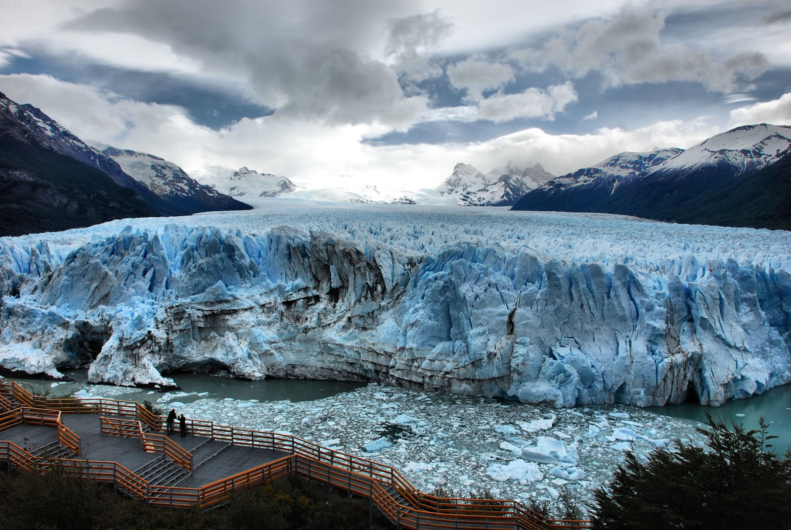 |
The Perito Moreno Glacier is located in the southwestern part of the province of Santa Cruz, in Argentina.
The length of the glacier is about 30 km, the area of the glacier is 250 km. square. The glacier moves along the slopes of the mountains to Lake Argentino at a speed of about 2 meters per day. Periodically, the glacier covers the lake, dividing it into 2 parts. The water in the southern part of the lake due to rivers and streams begins to rise compared to the northern part. The level difference is more than 30 meters, under the influence of water pressure, the isthmus collapses, and water flows rush to the northern part of the lake.
Global warming threatens to melt the glaciers. In the news now and then they talk about the threat of the disappearance of one or another icy river. In the meantime, you should hurry up and see a selection of the most beautiful glaciers in the world.
1. Biafo Glacier, Pakistan
Due to its secluded location in the heart of a highland region in northern Pakistan, the Biafo Glacier has remained virtually untouched by civilization. Traveling to the huge "Snow Lake" along the edge of the ice plain will require several days, which, due to the magnificence of the surrounding flora and fauna, will not seem boring. Hiking is best done in good physical shape. Otherwise, there is a great opportunity, instead of contemplating the pristine beauty of nature, to admire only the earth under your feet.
2. Perito Moreno Glacier, Argentina

There are as many as 13 glaciers in the Lago Argentino National Park, but the Perito Moreno Glacier is recognized as the most beautiful of them. An icy river, whose height is 60 meters, divides the high-altitude lake Argentino into 2 parts: the Rich Sea and the South Sea. Making their way through the glacier along the channel, the waters of these seas gradually destroy it, and thanks to this, tourists can admire the view of huge blocks of ice falling into the water. On the territory of the reserve you can meet guanacos, rhea ostriches and even a condor - the largest bird in the world.
3. Glacier Bay, Alaska

Glacier Bay is a giant national park located on the southeast coast of Alaska and is under the protection of UNESCO. Hiking tours on the territory of the reserve are practically absent - inspection of glaciers is carried out from an airplane or helicopter. However, you can watch the sparkling ice without leaving the hotel, which is located right on the territory of the park. In addition, the icebergs that have broken off from the edge of the glacier and the heaving ice blocks can be admired by cruising along the coast. In the surrounding waters of the reserve, you can stumble upon whales, walruses and even dolphins, and bears and deer live in coastal forests.
4. Furtwängler Glacier, Tanzania

Since the beginning of the century, the glacier, located almost on the equator, has been gradually melting and, according to scientists' forecasts, will completely disappear by 2020. Furtwängler is located at an altitude of more than 5000 meters, on the northern side of Kilimanjaro, near its summit.
5. Pasterze Glacier, Austria

The Pasterze, the largest of the 925 Austrian glaciers, is also slowly disappearing and, according to predictions, by 2100 less than half of its current size will remain. In the meantime, this seemingly motionless 9-kilometer-long icy river slowly descends from a height of 3500 meters to the foot of the Glosgrokner mountain.
6. Vatnajokul Glacier, Iceland

Iceland's largest glacier accounts for approximately 80 percent of the island's total ice cover, which takes its name from the frozen water. Its huge fields, dotted with cracks, stretch over 8,300 square kilometers. Competing with the cold beauty of ice is the lava frozen in the intricate curves of the nearby volcanic landscape. Favorite activities of tourists: descending into ice crevices, rock climbing on a glacier, riding snow rafts and swimming in the thermal springs of ice caves.
7. Yulong Glacier, China

Scientists have more than once foreshadowed the disappearance of China's southernmost glacier, but systematic observations of its movement, which have been carried out since 1982, refute pessimistic forecasts: depending on climate fluctuations, the glacier retreats several hundred meters up, then descends again. The lower border of the glacier is currently located at an altitude of about 4200 meters above sea level, and getting to it is not so easy due to the strong rarefied air.
8. Fox and Franz Josef Glaciers, New Zealand

Like a frozen waterfall, the glaciers flowing from the western slope of the Southern Alps come so close to the subtropical evergreen forests that their neighborhood seems completely unnatural.
9. Athabasca Glacier, Canada

Another rapidly melting glacier, which is considered the most beautiful in North America, has recently lost almost half of its volume. Currently, it has a length of only about 6 kilometers. Such a rapid melting turned into the fact that the glacier is constantly in motion and therefore it is strictly forbidden to walk along it alone, without a guide.
10. Antarctic

And, of course, most of the ice and snow can be seen in Antarctica, which, probably, was the reason for the increased popularity of the continent due to global warming. If in the 1990s 6-7 thousand people traveled here during the season, then last year the number of tourists reached 45,000, in connection with which the number of incidents that harm the ecology of the region increased. Therefore, quite recently, 28 countries conducting scientific activities in Antarctica signed an agreement to limit tourism to the mainland.
2016-06-22To see the most beautiful glaciers in the world with your own eyes, you do not have to go to the ends of the world - to Antarctica or the North Pole. Many impressive glaciers in all their beauty and scale are closer. You can always go to Norway or Iceland, for ski resorts in the Alps, and if you are traveling in Latin America, do not miss the opportunity to make an amazing trip to Patagonia - a piece of untouched nature at the end of the world.
We present the most famous, largest mountainous and simply beautiful glaciers in the world that are worth a visit.
The most impressive glaciers:
- Uppsala, Argentina
- Margerie, Alaska
- Perito Moreno, Argentina
- Vatnajokull, Iceland
- Pastoruri, Peru
- Fox, New Zealand
- Grey, Chile
- Serrano and Balmaceda, Chile
- Tasman, New Zealand
- Furtwangler, Tanzania
- Bosson, France
- Aletsch, Switzerland
- Mer de Glace, France
- Briksdal, Norway
- Malaspina, Antarctica
- Jokulsarlon, Iceland
- Stubai, Austria
Uppsala Glacier, Argentina
The Upsala Glacier is located in Patagonia, Argentina. It is 60 kilometers long, 70 meters high with a total area of 870 km².
Uppsala Glacier, Argentina (photo: 7-themes.com)
Franz Josef Glacier, New Zealand
The glacier is located on the west coast of New Zealand, 23 km north of Fox Glacier. Nearby is the village of the same name and Lake Mapurika, where you can go in for sports, recreation and fishing, canoeing.
Franz Josef Glacier, New Zealand (Photo: hotels.com)Margerie Glacier, Alaska
Discovered in 1888, the Margerie Glacier (34 km long) is located in Alaska, on the border with Canada. The glacier was listed as a UNESCO World Heritage Site in 1992.
Margerie Glacier, Alaska (Photo: earthporm.com)Perito Moreno Glacier, Argentina
About 50 km from El Calafate in Argentina is the Natural Park of the Glaciers, in which Perito Moreno is one of the most impressive. It is 15 km long and 5 km wide and is also listed as a UNESCO World Heritage Site.
Perito Moreno Glacier, Argentina (photo: moon.com)Vatnajökull Glacier, Iceland
Located in Iceland, Vatnajökull is the island's largest glacier. Vatnajökull National Park covers 13% of the entire island, covering an area of 13,600 km².
Vatnajökull Glacier, Iceland (photo: go4travelblog.com)Pastoruri Glacier, Peru
Peru is one of the countries in Latin America that has large quantity glaciers: about 3000 throughout the country. But in 35 years, Peru's glaciers have lost 35% of their area. The Pastoruri glacier is just one of the disappearing ones.
Pastoruri Glacier, Peru (photo: journeymachupicchu.com)Fox Glacier, New Zealand
Fox Glacier is located in the heart of New Zealand, on its west coast. It is quite often visited by tourists, special tours are organized there.
Fox Glacier, New Zealand (photo: nztravelorganiser.com)Gray Glacier, Chile
Gray Glacier is located in the Torres del Paine Natural Park and is one of the most visited in the country. Its dimensions are impressive: 300 km² of area and 25 km in length. It flows into Gray Lake, forming icebergs of dazzling blue color.
Gray Glacier, Chile (photo: jennsand.com)Serrano Glacier and Balmaceda, Chile
The Serrano and Balmaceda glaciers are located in the Patagonia region of Chile. Both are in O'Higgins National Park, the largest park in Chile. They can be seen during river cruises.
Serrano Glacier and Balmaceda, Chile (photo: blog.tirawa.com)Tasman Glacier, New Zealand
Tasman is located in New Zealand, in the Canterbury region, being the longest glacier on the island (27 km). It is located in the Mount Cook National Park, which has a total of 60 glaciers.
Tasman Glacier, New Zealand (photo: waitingroompoems.wordpress.com)Furtwängler Glacier, Tanzania
As the ice cap of Kilimanjaro, Furtwängler sits atop the most famous mountain in Tanzania.
Furtwängler Glacier, Tanzania (photo: poul.demis.nl)Bosson Glacier, France
The Bossons Glacier is a stream of ice and snow that descends from the summit of Mont Blanc. Not far from here is the Chamonix Valley.
Bosson Glacier, France (photo: parcdemerlet.com)Aletsch Glacier, Switzerland
In the canton of Valais in southern Switzerland lies the Aletsch Glacier, the largest of the Alpine glaciers. It holds the record including 27 billion tons of ice. The Aletsch region is included in the UNESCO World Heritage List. Lake Märjelen at the foot of the glacier is fed by the melting of its ice and snow.
Aletsch Glacier, Switzerland (photo: artfurrer.ch)Mer de Glace Glacier, France
The glacier, whose name translates as "Sea of Ice", is 7 km long and is the largest glacier in France. It is located in the Chamonix Valley.
Mer de Glace Glacier, France (photo: odyssee-montagne.fr)Briksdal Glacier, Norway
Briksdal is located in the west of Norway, in the Jostedalsbreen National Park. This glacier descends from a height of 1700 meters above sea level, forming three lakes.
Briksdal Glacier, Norway (photo: smashwallpapers.com)Malaspina Glacier, Antarctica
Malaspina is a foothill glacier, that is, its formation occurs as a result of the confluence of several valley glaciers. The area of the Malaspina Glacier is 2000 km².
Malaspina Glacier, Antarctica (photo: glacierchange.org)Jokulsarlon Glacier, Iceland
Jokulsarlon is a glacial lake in Iceland, the most famous in the country. Its name means "glacial lagoon".
Jokulsarlon Glacier, Iceland (photo: glacierguides.is)Stubai Glacier, Austria
The Stubai Glacier is located in the Tyrolean Valley. This is one of the most famous glaciers in Austria and there are many ski slopes within it.
Stubai Glacier, Austria (photo: tyrol.tl)Natural formations, which are accumulations of ice. On the surface of our planet, glaciers occupy more than 16 million km2, that is, about 11% of the total land area, and their total volume reaches 30 million km3. More than 99% of the entire area of the Earth's glaciers belongs to the polar regions. However, glaciers can be seen even close, but they are located on the tops of high mountains. For example, the highest peak - - is crowned with a glacier, which is located at least 4500 m.
Glaciers form on areas of the earth's surface, provided that the amount of solid precipitation over many years exceeds the amount of precipitation that can melt or evaporate. The line above which the snow that has fallen during the year does not have time to melt is called the snow line. The height of its location depends on. In the mountains located near the equator, the snow line is at an altitude of 4.5-5 thousand meters, and towards the poles it drops to the level of the ocean. Above the snow line, glaciers form from the accumulating and compacting snow there.
Depending on the place of their formation, cover glaciers and mountain-valley glaciers are distinguished.
Sheet glaciers. They occupy 98.5% of the total area of glaciers on Earth and form where the snow line is very low. These glaciers are in the form of shields and domes. The largest ice sheet on Earth is the Antarctic. The thickness of the ice here reaches 4 km with an average thickness of 1.5 km. Within a single cover, individual ice streams are distinguished, flowing from the center of the mainland to the periphery; the largest of them is the Bidmore Glacier, flowing down from the mountains of Victoria; it is 180 km long and 15-20 km wide. Along the edge of the ice sheet, large glaciers are widespread, the ends of which are afloat in the sea. Such glaciers are called shelf glaciers. The largest of them in Antarctica is the Ross Glacier. It is twice the size of the territory.
The other largest ice sheet of the Earth is, covering almost the entire territory of the huge. The glaciers of other regions are much smaller in size. Greenlandic and often descend to the coastal parts of the ocean. In these cases, blocks of ice can break off from them, turning into floating sea mountains -.
Cover glaciers are found on the surface of the land, regardless of it, and the relief is almost not reflected in the nature of the surface of the glacier.
mountain glaciers. They differ from integumentary ones in significantly smaller sizes and a large variety of forms, which is determined by the relief of the place of their occurrence. If the movement of sheet glaciers occurs from the center of the ice sheet to the periphery, then the movement of a mountain glacier is due to the slope of the underlying surface and is directed in one direction, forming one or more streams. If glaciers are located on flat tops, then they have a loaf-like shape; glaciers covering form ice caps. Many glaciers are bowl-shaped, filling depressions in slopes. The most common type of mountain glaciers are valley glaciers that fill river valleys. Mountain glaciers are located at almost all latitudes - from the equator to the polar. The largest mountain glaciers are in Alaska, in, in the Pamirs, and. The following zones are distinguished in the structure of glaciers:
Glacier feeding area. Snow accumulates here, which does not have time to completely melt during the summer period. It is here that a glacier is born from the snow. Snow is deposited every winter, but the thickness of the layer depends on the amount of precipitation falling in a particular place. In Antarctica, for example, the annual snow layer is 1-15 cm, and all this snow goes to replenish the ice sheet. The east coast accumulates 8-10 meters of snow per year. Here is the "snow pole". In the areas of glacier feeding in Tien Shan, Pamir, 2-3 meters of snow accumulate per year, and this is enough to restore summer melting costs.
Snow turns to ice in the food area different ways. First, there is an enlargement of the crystals, a decrease in the space between them. This is how firn is formed - a transitional state from snow to ice. Further compaction under the overlying snow leads to the formation of milky ice (due to numerous air bubbles);
Ablation area(lat. ablatio - demolition, decline). In this area, a decrease in the mass of the glacier occurs during melting, evaporation, or separation of icebergs (near the sheet glaciers). Glacier ablation is especially strong in the mountains below the snow line, which contributes to high water starting from the glacier. For example, in the Caucasus, in Central Asia, etc. For some rivers of Central Asia, the share of glacial runoff reaches 50-70% in summer. But the amount of water given off by glaciers varies greatly depending on the melting conditions in a given summer. Glacier researchers also conducted a number of experiments on the Tien Shan glaciers to artificially increase the melting of glaciers in order to increase the flow of melt water to cotton fields in dry years. It was found that it is possible to strengthen from glaciers by covering their surface with coal dust. On clear days, melting increased by 25% (a dark surface absorbs the sun's rays more than light ones). However, until methods of artificial replenishment are developed, the method is not recommended.
Glaciers tend to flow, revealing plastic properties. This forms the tongue of the glacier, one or more. The speed of movement of glaciers reaches several hundred meters per year, but it does not remain constant. Since the plasticity of ice depends on , the glacier moves faster in summer than in winter. Glacial tongues resemble rivers: atmospheric precipitation gathers in a channel and flows down the slopes.
The work of the glacier can be both destructive (denudation) and accumulative (). At the same time, the glacier is also all the material that has fallen into it. The denudation activity of the glacier consists in the processing and deepening of natural depressions in the relief. The accumulative work of the glacier occurs in the glacier feeding area, where snow accumulates and turns into ice. Due to the accumulative work of the glacier in the area of \u200b\u200bits melting, the deposited by it creates peculiar landforms. For areas of existence of mountain glaciers, such a phenomenon is characteristic as. Thanks to them, the glacial regions are unloaded. An avalanche is a name given to snow falls that slide off mountain slopes and entrain snow masses on their way. Avalanches can occur on slopes steeper than 15°. The causes of avalanches are different: looseness of snow in the first time after its fall; rise in temperature in the lower snow pressure, thaw. In any case, it has tremendous destructive power. The impact power in them reaches 100 tons per 1 m2. The impetus for the beginning of a snowfall can be the most insignificant imbalance of the overhanging snow masses: a sharp cry, a gun shot. In avalanche-prone places, work is underway to prevent and remove avalanches. The most frequent avalanches in (they are called here "white death" - they can destroy an entire village), in the Caucasus.
Glaciers play an important role not only in nature, but also in human life. This is the greatest storage of fresh water, so necessary for man.